The merits to humanity of the navigators of the Middle Ages and the era of the Great Geographical Discoveries are great. At the same time, the methods that they used in their voyages to determine the position of the vessel, to map the outlines of the coast and determine their length, to put it mildly, left much to be desired. As a memory of some of these techniques, specific terms have been preserved in maritime navigation to this day.
A device for measuring the speed of a vessel is still called "lag" today - from English word"log" - a log, a wooden chock. These chocks were tied to a rope with knots and thrown from the bow of the ship overboard. The hourglass recorded the time during which the lag moved to the stern, and then the number of knots that passed through the hands of the sailor bleed the rope was counted. From here came the marine term - "knot" (in English - "knot"), a measure of the speed of the vessel (one nautical mile per hour or 1.85 km / h).
European sailors of the 15th-16th centuries, like the Arab "sinbads" of the 9th-12th centuries, did not use the concept of "latitude", since it could be determined only at the moments of lunar and solar eclipses, which did not occur at all often. The definitions of longitude on the high seas according to the distance traveled by the ship, which was calculated based on the course of the ship and its speed, were so approximate that many Pacific islands and archipelagos were successfully “discovered” by the Portuguese and Spaniards several times. One of Magellan's helmsmen, for example, made a mistake in determining the longitude of the Philippines at 52 ° 55 "(!).
By the middle of the 18th century, navigators knew the outlines of all the main continents and islands of the Atlantic, Pacific and Indian Oceans, with the exception of Antarctica. However, their position was determined very inaccurately, and most of the maps of that time were almost impossible to use. In this regard, many islands and archipelagos, for example, the Pacific Ocean, after the discovery were "lost" for many years.
Only in 1750, on the basis of an improved “quadrant”, a new “sextant” device was created, which for the first time made it possible to determine the degree of latitude from the board of a ship. Longitude, due to the lack of the ability to accurately determine the time in sea conditions, was not determined at all. The precise pendulum clock, invented in 1657 by Christian Huygens, was unreliable at sea. In 1707, due to a flagship navigator's gross error in determining longitude, the English fleet ran into the rocks of the Isles of Scilly, as a result of which many English sailors died needlessly. Only after that, in 1714, the English Parliament announced a prize of 20 thousand pounds sterling to the inventor of accurate marine clocks. The criterion for their accuracy was the condition that during the flight from England to the West Indies and back, the error of the course did not exceed two minutes.
In 1729, the Commission of Parliament was offered the first example of such a watch, made by the English master John Harrison and passed the test for accuracy in swimming to Lisbon. It took another thirty years for the author of the first "chronometer" to bring his brainchild to perfection. Garrison's fourth clock model, proposed by him in 1761 at the Bureau of Longitudes under the British government, was less than two minutes behind on the flight to Jamaica and back, and on the flight to Barbados and back (156 days), the delay was only 15 seconds. After that, almost fifteen more years passed in disputes and courts, during which John Garrison defended his copyright for the invention. Finally, in 1775, the eighty-two-year-old poor fellow inventor received the prize, after which he died a year later. The fate of geniuses, as we see, has not been easy at all times.
Thus, at the turn of the 18th and 19th centuries, marine science finally received a watch that, despite the pitching, steadily showed the exact time needed to measure geographic longitude. After that, the exact "binding" of open lands to the map began, which made it possible to determine the real boundaries and sizes of individual parts of the oceans.
Navigation in Latin means "navigation, navigation." This component complex of marine sciences, which stood out from them in the process of development of navigation. This includes sailing - focusing on navigational aids, nautical astronomy - which studies methods for determining the coordinates of a ship from celestial bodies; and means of navigation, with the help of which dead reckoning is carried out and the position of the vessel is determined.
The very history of people is inextricably linked with the sea and navigation. The remains of people who are more than 30 thousand years old have been found in North and South America, many of these ancient people swam across the ocean. How did they do it? Thor Heyerdahl, during his oceanic expeditions on the prototypes of ancient ships, proved that this is possible. The first ships are known to us from ancient Egyptian records - these are quite advanced ships on which the Egyptians carried out a brisk trade along the Nile and by sea. These records are over 4,000 years old. From this ancient time, the need for navigation has already arisen.
What questions did ancient sailors face? Yes, just like today. This is the definition of your location and the direction of the path. At first, busy sea trade routes ran along the coast, and navigation was carried out along coastal landmarks. If it was necessary to sail across the ocean, then before the eyes of the ancient travelers there was only one landmark - the stars. The directions of the cardinal points were determined by the movement of the sun. And for a long time watching the stars at night, you can distinguish among them motionless objects. This is the North Star in the Northern Hemisphere and the stars in the constellation of the Southern Cross in the Southern. Most likely, guided by these stars, ancient people mastered new spaces, populated the continents and islands. The ancients also noticed that although the stars move, the distances between them do not change. Before the eyes of the people was a stunning picture of a moving celestial sphere. Now we know that the Earth is moving and we are with it. But these observations laid the foundation for astronomy and celestial navigation.
Ancient Phoenician ship. Image on the sarcophagus
First navigation charts
In order to successfully navigate in space, people sought to build a model of this space in order to know where they were and where to go after all. Some nationalities used the oral tradition, when information about sea routes was transmitted in the form of stories or chants. Sometimes they also used knot writing. But even a schematic representation, a plan of the area, was more illustrative. And so the cards began to appear. The Polynesians who crossed the vast Pacific Ocean had woven mats with the designation of islands and reefs. The Egyptians painted on reeds. However, these maps, despite the great accuracy in the descriptions of specific areas and their features, did not answer the main question - where exactly is the navigator at the moment? How long does it take him to go to the selected port? There was already a fixed point of reference - these are the stars. It was necessary to come up with and decide how to mark your location on the map. But the original maps were unfortunately inaccurate, because it is difficult to plot the round surface of the Earth on the plane of the map without distortion. Moreover, according to ancient ideas, the earth was flat, which introduced even greater inaccuracy. However, trade developed, especially in the Mediterranean region. Gradually, vast knowledge was accumulated in navigation, astronomy and other sciences, later they were collected in ancient Greece. These sciences were developed later, during the Roman Empire. The Greeks, using their observations and collected information from their predecessors, mapped the outlines of known lands. To indicate the location of these lands and other objects, a grid of coordinates was put on the map. The invention of this widely known grid on maps of parallels and meridians also belongs to the ancient Greeks. The concept of latitude and longitude for determining one's location arose again in Greece as a result of constant observations of the position and height of the Sun during the day and the height of the stars above the horizon at night. The change in the position of the Sun was chosen as a measure of measurement. Observing the luminaries, even the Chaldeans divided the circle into 360 parts, where one part - a degree - was the movement of the Sun in the sky by the size of its disk. The degree was divided into 60 minutes of arc, since this people had a sexagesimal number system. This knowledge was assimilated and developed by the Greeks. Gradually, such concepts as the horizon, the ecliptic, and the celestial equator entered science. Without these astronomical concepts, it is impossible to determine the exact coordinates.

Modern 3D sky map
Already in the third century BC. The Greek scientist Eratosthenes determined not only that the Earth is round, but also very accurately calculated the circumference and radius of the earth's sphere. He used an equidistant cylindrical projection in his maps, which gave greater accuracy on maps showing small areas of the earth's surface. Another Greek scientist - Hipparchus - in the third century BC covered the whole earth with a grid of meridians and parallels. Now it became clear in which area of the map you need to find your coordinates. A little later, the Roman geographer Marinus of Tire makes exact nautical charts. For some areas, it calculates longitude and latitude very accurately and plots them on a grid of parallels and meridians. His information was subsequently used by the famous scientist Ptolemy in his writings. Marinus, like Eratosthenes, even tried to portray complete model Earth - globe. His calculations and maps were so accurate that they were adopted by the Portuguese in the 15th century.
The works of a later scientist - Ptolemy - gave a huge impetus to the science of geography and navigation. Ptolemy drew a map of the world in a conic projection, with parallels and meridians, he designated a grid of coordinates calculated in degrees, where latitudes were measured from the equator, and longitudes from the westernmost point of the then known world. He interviewed a huge number of merchants and sailors and quite accurately described the coasts and countries, even those that he had not seen. He described a huge number of new places and gave their coordinates. In addition to accurate information, he recorded on maps and inventions of people, so in his maps you can find, for example, lands inhabited by the people of dogheads and other miracles. In the future, after Ptolemy, nothing new was invented in cartography, and after the collapse of the Roman Empire, dark times came at all.

Ptolemy's map in modern processing. It accurately indicates the lands known to the Greeks at that time.
ancient navigational tools
The very first navigational tool was the eyes of an ancient navigator. But with the development of navigation, this was not enough. To accurately determine the angle of the luminaries above the horizon, special tools were required. This is how the gnomon first appeared, which was a tall pillar, by the ratio of the lengths of the pillar and the shadow from it, the time and height of the Sun above the horizon were determined. The gnomon in the form of a board with a pole on it was first used by the Greek merchant and navigator Pytheas to determine the latitude as early as the 4th century BC. The merchant violated the then existing prohibition and went beyond the Pillars of Hercules into the open Atlantic Ocean, where he made his observations. Despite the primitive device and excitement, the traveler took readings with an accuracy of a few arc minutes. Later, a quadrant was used for astronavigational observations. The quadrant was regular board carved out of stone or wood. On its surface were drawn vertical and horizontal lines and a 90° arc uniting them, divided into degrees and their parts. A ruler was placed in the center of the arc, which could move.
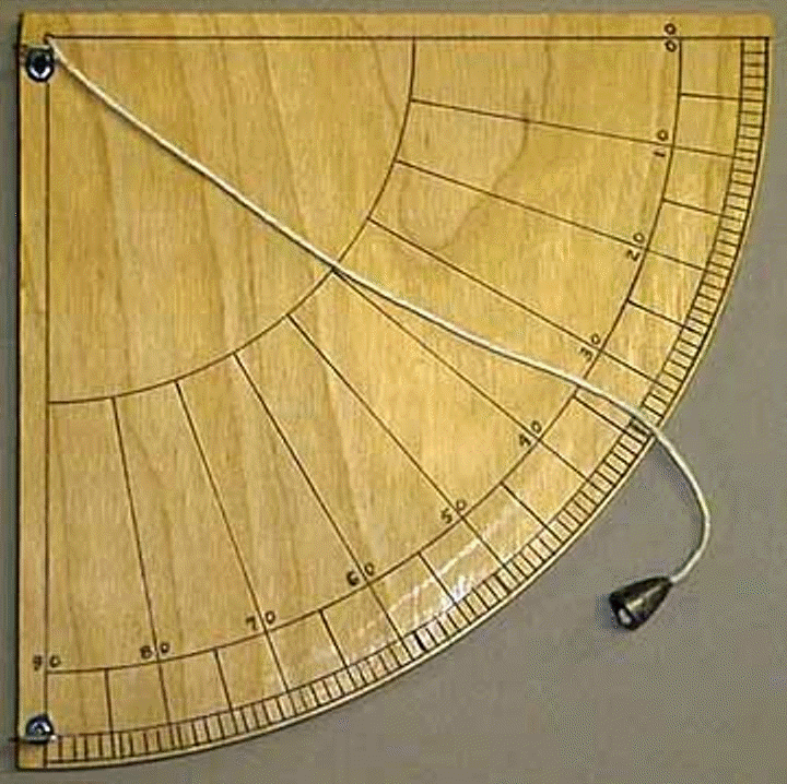
Quadrant
A more perfect instrument was the astrolabe, which was used from the second century BC. up to the 18th. The astrolabe was essentially a model of the celestial sphere with its important points, circles, poles and axis of the world, meridian, horizon, celestial equator and ecliptic. It was not easy to make observations with such an instrument. Observing the sun, moon or known stars, the ancient astronavigator led circles complex instrument V correct position, after which, using scales graduated on circles, he calculated the longitude and latitude for the observed luminary. The most famous mechanism that has come down to us is the ancient Greek device of 32 Antikythera gears, raised from the bottom of the sea. According to the surviving inscriptions on it, we can conclude that this is an astro-navigation device. The mechanism could calculate the motion configurations of the Sun, Moon, Mars, Jupiter, Saturn, lunar and solar eclipses. Estimated time of manufacture - the period between 100 - 150 years BC.

ancient celestial instrument
Another device that modern navigators cannot do without - the compass - was also invented in ancient times. The inventors of the compass - the Chinese, according to the records in their books, began to use the magnetic compass not only for religious purposes, but also for navigation about 300 years before our era. However, copies of the compass of a later period have come down to us. It was like a magnetized spoon, with a handle pointing south. The Chinese assigned their own color to each side of the world. For example, the south was associated with the color red - modern compasses follow this tradition.

Chinese compass
Location
Starting with the voyages of the Egyptians and Phoenicians, huge amounts of information about the coastline, ports of refuge, anchorages have been accumulated. This knowledge formed the basis of maps and was further used even by Europeans in the Middle Ages. Also, the ancient sailors, going out into the ocean, faced with such a phenomenon as the ebbs and flows. In the future, knowledge was systematized, and already in the ancient Greek sailing directions, for example, they wrote: “The whole Indian country has a lot of rivers and a very high tide and ebb, which intensify during the new moon and full moon for three days, and in the intermediate phases they are weaker” .
A certain difficulty in historical times was the accurate measurement of time and distance. To measure time, water or hourglass, and the distances were measured by eye. IN Ancient Greece to assist captains, a beacon system was also adopted. very famous Alexandrian lighthouse 120 meters high. Many sculptures placed on the shore also served as coastal landmarks for ships. The famous statue of the Colossus of Rhodes, 36 meters high, was visible for miles. And the entrance to large ports at night was illuminated by light - large bonfires.
The first seafaring schools
With the development of merchant shipping, with an increase in the number of sea voyages, the need arose for the transfer of knowledge. There are no references specifically to maritime schools of ancient times; most likely, knowledge was transmitted orally and in a close circle. One of the oldest known schools was the school of navigation in Polynesia. On the island of Raiatea, a place was discovered from which the expansion of the Polynesians to the rest of the Pacific Islands came from, and a place for transferring knowledge about maritime affairs and navigation - these were the first nautical schools. Representatives of the AMS Yacht Training Center visited this sacred place on the islands. In 2012 we plan to make a second expedition there.

"Tapu tapu marae" on Raiateya island. Dated to the 1st millennium BC. This is the surviving remains of one of the first schools of ocean navigation. Photo by Vladimir Vatrunin.
The first textbooks for sailors were probably written on a par with the invention of writing. One of the astronomical navigation textbooks known to us was compiled by Thales of Miletus as early as 600 BC. In Greece, the teaching of astronomy, including astronomy for navigation, was carried out in higher educational institutions of that time. The classical schools of navigation known to us were created much later, in the Middle Ages.
Determination of geographical longitude in antiquity.
Or why are there 24 hours in a day?
But really, why are there 24 hours in a day, and not 20 or 30? Well, it could have been 25 for the convenience of counting. There are many discussions and explanations about this. Here is another version.
Let's start with specific questions. Who, yes, with such accuracy, had to divide the day into such small and even segments in almost prehistoric times? Did the division of the day into day and night or a more detailed division of the day into day, evening, night and morning was not enough? There was enough for everyone. In Russian, there are also the concepts of midnight, midnight, early morning, dawn, sunset, noon, which further expanded the division of the time of day into smaller periods of time. A similar division of the day into smaller segments of the time of the day, albeit different in duration, exists in almost all languages and among all peoples. For example, lovers who agreed on a meeting, in those days, already knew quite exactly when to come to a meeting and how much to expect a belated partner would have to the maximum. The answer is quite simple, the day was divided into 24 hours by those who needed it for professional reasons. And only much later did this professional division of the day become common and familiar to the rest of the population.
So who are these pros who divided the day into 24 hours? These are sailors from ancient times. It was they who came up with the idea of dividing the day into 24 hours, but in order. To determine their location, the sailors needed to be tied to some kind of global landmarks in space and time. Everyone knows that the planet Earth looks like a ball. This ball rotates around its axis and still moves around the Sun. The Earth rotates once a day around its axis and in a year it rotates around the Sun. If it is very simplified, then we will assume that the Sun "hangs" strictly above the Equator, and the axis (or poles) of the Earth are at right angles to the Earth-Sun line. Even in ancient times, it was noticed that the north pole (or axis) of the Earth looks at the North Star in the constellation Ursa Minor, and the south pole is directed to the constellation of the Southern Cross. For convenience, the globe was divided into the Northern Hemisphere and the Southern. At night, in the northern hemisphere, the North Star can be determined by the North Star, and in the southern hemisphere, the South is found by the constellation of the Southern Cross. Standing facing the North, you can determine where the other cardinal points will be. Behind the back will be the South, right shoulder will point to the East, the left shoulder will point to the West. The oldest navigational device was magnetic compass. With a compass at any time of the day and in any weather, you can determine the cardinal directions.
On land, a traveler, having gone to the West, for example, knows that he must return by moving to the East. At sea, a sailor can sail to the same West from some island, but winds, currents and other factors will take him to no one knows where, and if the island is not visible, then in which direction should you send your boat to return to the same island? Here, knowledge of only the cardinal points is no longer enough. There is only one right direction, all other parties will lead the sailor away from his native island.
Let's go back to the simplified Earth-Sun model. There is a very convenient place on Earth, it is the Equator. At the Equator, the Sun at noon, located at the Zenith (at the highest point), should shine directly overhead, and if you go from the equator to the north side, then the Sun will already shine from the South. If you go to the south side, then the Sun will shine from the north side. Having left the Equator, it is enough to simply determine which direction to go in order to return to the Equator line. On our model, you can also see that moving from the Equator, for example, to the North Pole, the Sun will gradually shift from the Zenith to the South and at the Pole will shine at the very edge of the horizon. Standing at the pole, you can see the Sun not setting beyond the horizon, moving above the very horizon, it will shine all day and night.
By the way, knowing at what angle to the horizon the Sun was at Zenith over the native island (yesterday, the day before yesterday), you can quite accurately determine to the south or north whether the ship was carried away during the voyage. Accordingly, if the Sun rose at noon higher than over the native island, then the island is somewhere in the South. If the Sun is lower than it should be, then the island is somewhere in the North.
Here it is necessary to make an explanation and make an addition. Let's try to see how the length of the shadow from the Sun changes during the day. To do this, on a flat area, we will stick a stick into the ground and we will mark the end of the shadow from the stick closer to noon. For example, small pegs. It is better to start marking the length of the shadow no later than half past ten. The shortest shadow from the stick will indicate True Noon. After conducting this experiment, you will see that True (or Astronomical) noon in a given area does not at all coincide with noon by the clock or twelve o'clock in the afternoon of Local time. At the same time, you will find out the angle of elevation of the Sun above the horizon in your area in True, only for your area Noon. The angle of the ground-end of the stick-pegs can be measured. This will be the Latitude angle of your area. Now let's draw a circle and mark the Equator on the circle. Next, we divide the circle from the Equator to the poles by 90 degrees from the center of the circle. Let's put marks on the circle in increments of 10-15 degrees. Where the zero degree will be the Equator, and 90 degrees the North or South Pole. At the same time, mark the latitude angle of your area and see where you are on the model of the globe. The greatest latitude is at the Equator. The remaining latitudes encircle the entire globe in parallel lines, therefore latitudes are also called parallels. As if cutting the entire ball into slices gradually decreasing in diameter. Knowing your latitude, you can go to the latitude or parallel of the island, but then a new problem arises, where to sail to the East or West to find the island. To do this, you also need to know the longitude of the island.
What is Longitude? Imagine a peeled orange. The slices of this orange from one pole through the Equator to the other pole will be the lines of Longitude or Meridians. The entire planet is divided into 360 degrees around the circumference of the Equator. There is a zero longitude or zero meridian, Greenwich. From the zero meridian, longitude goes to the West, these will be Western longitudes, and to the East. There, respectively, will be Eastern longitudes. The maximum longitude either in the East or in the West will be 360:2 = 180 degrees. At 180 degrees of longitude, the countdown begins on the entire globe. It is at 180 longitude that a new day or a new day begins. But the countdown of longitudes is from the zero meridian. And when they determine the place of some point on the planet, they say: So many degrees of South (or North) latitude. This means South or North of the Equator. And so many degrees East (or West) longitude. Accordingly, to the East or West from the Greenwich meridian. When designating, they can point to such and such a parallel and to such and such a meridian, which is one and the same. But the latitude (parallel) is always indicated first, and only then the longitude (meridian) is indicated. For example:
Moscow coordinates Latitude: 55°45;07; NL Longitude: 37°36;56; o.d. Height above sea level: 144 m
Coordinates of my Kazan Latitude: 55°47;19; NL
Longitude: 49°07;19; o.d.
Height above sea level: 61 m
Paris coordinates 48° 51’ 12" (48° 51’ 20) north latitude
2° 20’ 55" (2° 20’ 92) East
Height above sea level 40; 60 m
If you divide 360 degrees by 24 hours, which is the time the Earth rotates in one day, you get 15 degrees per hour. Knowing the Longitude at some point on the planet, you can determine the lag or advance of time from the time of the Zero Meridian. And vice versa, knowing the time difference from the time of the Zero Meridian, you can determine the Local Longitude. For example, how is it done today?
We turn on the receiver and by the sound signal we check our clocks with the Universal Time. The receiver sounds the time signals of the local capital. In Russia it is Moscow. Moscow time (MSK) differs from Universal Time (Greenwich Mean Time) by plus 2 hours. Then, according to Universal Time and Astronomical Noon, at a specific location of our location, we determine the difference in time, and from this difference we determine the longitude of our location. As you remember, the Latitude can be determined right on the spot and as a result we get the Coordinates of our location. You can also determine the coordinates using navigators. I do not argue that it is faster and easier. But not so accurate. With the help of a conventional receiver, coordinates are determined with an accuracy of up to 20 centimeters.
In the Age of Historical Discoveries (this is the 15th-19th centuries), there were no radios, navigators, and even broadcasting. The ships sailed away for years without any connection with their superiors. To determine the exact time, navigators carried with them a whole bunch of very accurate Chronometer watches. Naturally, even the most accurate clocks can slightly rush or lag behind, which is why they took several chronometers at once in order to calculate more or less accurate time using the arithmetic mean time, and then it was possible to map relatively accurate Coordinates of open lands and find out your location.
There is a small inconsistency in the above. Why hasn't anyone gone anywhere before? In the sense that until 24 hours a day was approved, World Time, the Zero or Greenwich meridian, did not invent high-precision clocks and sufficiently reliable seaworthy ships, sailed only along the coasts "in view of the visibility of the Earth" and the inhabitants of islands in the oceans further than "knee-deep in the water" did not depart from your island? Then how did these islanders get to their islands and how did the fishermen on their ships find their way back to their islands? Moreover, even before the invention of all the novelties described above, detailed maps of the planet with continents and islands already existed, even with those that were rediscovered much later than the invention of chronometers and World Time. Sounds unbelievable, but it was. This means that even before that there were some reliable ways to determine coordinates without the tales of current scientists “On coastal navigation for long-distance navigation”. Need examples? Yes, whatever.
Pomors from the Russian North through the White Sea went to the islands of the Spitsbergen archipelago. And from there, the mainland is not visible, but this did not prevent the Pomors from returning. On the islands of Oceania, local fishermen on their fragile pirogues could sail for weeks to the desired island and return to their family in the same way. But smart scientists refer as a model of a navigator of distant times to a certain navigator Odysseus, who wandered around the Mediterranean for 25 years until he found his native island. During this time, Odysseus grew old, his wife almost got married, his son grew up ... That's how the famous hero hurried home from the war on a neighboring island. Interestingly, allies from all over the Mediterranean gathered for that war in an instant, no one was late for the planned battle for twenty-five years due to ignorance of the road. Probably, Odysseus's companions and himself lost their memory in the war, which is why they returned for so long.
There is a version that the ancient navigators somehow navigated by the stars. The version is beautiful, but no one knows how specifically they were guided. According to my version, the ancient navigators were guided by the moon. It is known that the Moon makes one revolution around the Earth in 28 days. Therefore, in a day the Moon passes 360 degrees: 28 = 12.857 degrees. Now we divide 12.857 degrees by the degree size of the moon (0.53) and we get 24.258 moon diameters. These are the same 24 hours or a period of time that the Moon passes in a day across the sky. The stars in the sky are also moving towards the Moon at a speed of 30 degrees per month, but this movement can be taken into account and a landmark for the Moon can be found where this Moon should be tomorrow or in a week, a month. The essence of determining longitude according to the Moon is as follows: On the platform fixed in space, the Moon will move 24 diameters the next day at the same time. If we move 1000 kilometers to the east (or west) in a day, then the Moon, respectively, will not reach one diameter (or it will go over an extra diameter), which is not difficult to note. Of course similar way determination of longitude is suitable at any distance from the point of determination in latitude, at least on the other side of the planet. The closer to the polar regions, the more accurate the measurements will be. The coast-dwellers of the north had a home-made device “solar compass Matka”, and so, using this device, the coast-dwellers could easily determine both latitude and longitude. And also to make detailed maps and coasts and islands. There are suggestions that the Russian Pomors inhabited the Far East coast and the lands of Eastern Siberia even before the birth of Christ. That is, they reached the Pacific Ocean by the Northern Sea Route and knew how to get back by dry land.
What homemade appliances or even, perhaps, the inhabitants of Oceania simply determined the latitude and longitude on their fingers, I don’t know, but it was unlikely that it was very difficult and abstruse. It was the main thing!
Any technical problem has many solutions. You just need to find the most profitable or simple.
I would be very grateful if my reasoning on determining longitude on the Moon was calculated and brought to practical use by pros from Astronomy or other specialists familiar with the physics of the movement of astronomical bodies. I promise collaboration.
Page 2 of 2
So was the information contained in the portolans reliable? I think that it depended on the tasks assigned to them. For solving "local" applied problems - getting from point A to point B - they were quite suitable. Navigation in the Mediterranean was fairly well understood, as it was constantly supported by major pilot schools, such as the Genoese, Venetian or Lagos. For the knowledge of the whole world, portolans were completely unsuitable, more confusing researchers than helping them.
Only from the end of the 13th century, the first attempts at ocean navigation, as well as the wider use of the compass, revealed the need for a real display on a flat sheet of paper of the relief of the coast, indicating the winds and the main coordinates.
After the 14th century, portolans are often accompanied by rough contour drawings of the Mediterranean coast and the Atlantic coasts of Western Europe. Gradually, ships leaving for ocean voyages begin to be included in the work of compiling more accurate portolans and drawings.
Somewhere by the beginning of the 15th century, real navigation charts. They already represent a complete set of information for the pilot: coast relief, a list of distances, indications of latitude and longitude, landmarks, names of ports and local inhabitants, winds, currents and sea depths.
The map, the successor to the mathematical knowledge obtained by the ancients, the ever more accurate knowledge of astronomy and the thousand-year experience of navigating from port to port, becomes one of the main fruits of the scientific thought of the pioneers: from now on, during long voyages, it is necessary to draw up reports necessary for a complete display of knowledge about the world. Moreover, the first ship's logs! Of course, sea travel has been described before, but now it is starting to become a regular occurrence. He was the first to introduce a mandatory log book for the captains of his caravels. The captains had to record daily information about the coast with the indication of coordinates - a matter extremely useful for compiling reliable maps.
Despite the desire to clarify and verify that drove the most famous cartographers (Fra Mauro in 1457 claimed that he could not fit all the information that he managed to collect into his map), fantasies, legends, fiction surrounded any cartographic work with a kind of “folklore” halo : on most maps dated before the 17th century, we see how, in place of little-known or insufficiently explored regions, images of various monsters appear, drawn from ancient and early Christian mythologies.
Quite often, the compiler, describing the inhabitants of remote corners, resorted to speculation. Areas that were explored and fell under the rule of European kings were marked with coats of arms and flags. However, the magnificently painted vast wind roses could not be useful if they were incorrectly oriented or marked in erroneous lines of "diamonds" (a primitive system of orientation that preceded the system of meridians and parallels). Often the work of a cartographer became a real work of art. At the courts of kings, planispheres were looked at like canvases, sailors set off on long journeys were guessed behind them, monsters caused shivers, the distances traveled and intriguing names fascinated. It took a long time before the custom of making a map decorative gave way to really useful cartography, devoid of all fiction.
This explains the incredulity with which the great navigators, and above all Christopher Columbus, belonged to the decorated maps of the 15th century. Most sailors preferred to rely on their knowledge of the winds, bottom topography, currents and observations of the celestial sphere, or tracking the movement of schools of fish or bird flocks, in order to navigate the vast expanses of the ocean.
Undoubtedly, it was in the 15th century, thanks to the Portuguese navigators, and then the voyage of Columbus and, finally, the round-the-world voyage of Magellan in 1522, that mankind was able to practically test the calculations of the ancient Greeks and ideas about the sphericity of the Earth. Many navigators now in practice received specific knowledge testifying to the sphericity of our planet. The curved line of the horizon, the shifting of the relative heights of the stars, the rise in temperature as we approached the equator, the change of constellations in the southern hemisphere - all this made obvious the truth that contradicted Christian dogma: the Earth is a ball! It remained only to measure the distances that had to be covered on the high seas in order to reach India, in a southerly direction, as the Portuguese did in 1498, or in a western direction, as it seemed to Columbus, when in 1492 he met an insurmountable obstacle in his path in face of the Americas.
Columbus was well acquainted with the cosmographic literature of that time. His brother was a cartographer in Lisbon, and he himself tried to build a globe on the basis of available atlases, modern and ancient treatises on cosmography. True, he made, following his Imago Mundi (1410), a gross mistake in estimating the distance between Portugal and Asia, underestimating it (there is a hypothesis that he did this deliberately). However, he heeded the advice of eminent cartographers such as (who believed in the sea route to the west), (the future Pope Pius II) and (later the author of a fairly accurate globe).
Beginning in 1435, Portuguese and Italian sailors made it a habit to sail at a distance from the African coast to avoid dangerous areas and changeable winds. The coastal zone, replete with reefs and shoals, indeed presented an obvious danger of shipwreck.
However, such a significant distance from the coast that it is lost from sight presupposes the ability to navigate the open sea in a flat, uniform space without lighthouses, limited only by the horizon line. And the sailors of the 15th century lacked the theoretical knowledge of mathematics and geometry necessary to accurately determine their location. As for measuring instruments, things were even worse with them. Until the 16th and 17th centuries, none of them were really good at what they did. The maps, although constantly updated, had significant gaps.
In order to appreciate the extraordinary courage of the navigators who explored the near and then the far Atlantic, one must remember what miserable means they had at their disposal to determine their location on the high seas. The list will be short: the sailors of the 15th century, including Christopher Columbus, had practically nothing that would help them solve the three main tasks of any navigator going on a long voyage: to keep a course, measure the distance traveled, know with accuracy their present location.
The 15th-century sailor had only a primitive compass (in various variations), a crude hourglass, error-ridden maps, approximate tables of declination of the luminaries and, in most cases, erroneous ideas about the size and shape of the Earth! In those days, any expedition across the ocean became a dangerous adventure, often fatal.
In 1569 Mercator made the first map conformal cylindrical projection, and the Dutch Luca Wagener brought into use atlas. This was a major step in the science of navigation and cartography, because even today, in the twenty-first century, modern nautical charts are compiled in atlases and made in the Mercator projection!
In 1530 a Dutch astronomer Gemma Frisia(1508-1555) in his work “Principles of Astronomical Cosmography” proposed a method for determining longitude using a chronometer, but the lack of sufficiently accurate and compact clocks left this method purely theoretical for a long time. This method has been named chronometric. Why did the method remain theoretical, because the clock appeared much earlier?
The fact is that watches in those days could rarely go without stopping during the day, and their accuracy did not exceed 12-15 minutes a day. And the clock mechanisms of that time were not adapted to work in conditions of sea rolling, high humidity and sudden changes in temperature. Of course, apart from the mechanical maritime practice hourglasses and sundials were used for a long time, but accuracy sundial, plant time hourglass were completely insufficient for the implementation of the chronometric method for determining longitude.
Today it is believed that the first accurate clock was assembled in 1735 by an Englishman John Harrison(1693-1776). Their accuracy was 4-6 seconds per day! At that time it was simply fantastic accuracy! And what's more, the watch was adapted for sea travel!
Ancestors naively believed that the Earth rotated uniformly, lunar tables were inaccurate, quadrants and astrolabes introduced their own error, so the final errors in calculating coordinates were up to 2.5 degrees, which is about 150 nautical miles, i.e. almost 250 km!
In 1731, an English optician improved the astrolabe. The new device, called octant, made it possible to solve the problem of measuring latitude on a moving ship, since now two mirrors made it possible to simultaneously see both the horizon line and the sun. But the octant did not get the glory of the astrolabe: a year earlier, Hadley had designed sextant- a device that made it possible to measure the position of the vessel with very high accuracy.
Principal device sextant, i.e., a device that uses the principle of double reflection of an object in mirrors, was developed back Newton, but was forgotten and only in 1730 was reinvented by Hadley independently of Newton.
The marine sextant consists of two mirrors: an index mirror and a stationary translucent horizon mirror. Light from a luminary (star or planet) falls on a movable mirror, is reflected on the horizon mirror, on which both the luminary and the horizon are visible at the same time. The angle of inclination of the pointing mirror is the height of the luminary.
Since this site is about history and not about navigation, I will not go into the details and features of various navigational instruments, but I want to say a few words about two more instruments. These are lot() and lag().
In conclusion, I would like to briefly dwell on some historical dates in the history of the development of navigation in Russia.
One thousand seven hundred and first year is perhaps the most significant date in domestic navigation, since this year the emperor Peter I issued a decree on the establishment of "Mathematical and Navigational, that is, nautical cunning sciences of learning." Year of birth of the first national navigation school.
Two years later, in 1703, the teacher of this school compiled the textbook Arithmetic. The third part of the book is entitled "Generally about the earthly dimension, and even belongs to navigation."
In 1715, the senior classes of the school were transformed into the Naval Academy.
1725 is the year of birth of the St. Petersburg Academy of Sciences, where such luminaries of science taught as, Mikhail Lomonosov(1711-1765). For example, it was Euler's astronomical observations and mathematical description of the motion of the planets that formed the basis of high-precision lunar tables for determining longitude. Bernoulli's hydrodynamic studies made it possible to create perfect logs for accurately measuring the speed of a vessel. Lomonosov's works dealt with the creation of a number of new navigation instruments, which served as prototypes for instruments that are still in use today: course plotters, recorders, logs, inclinometers, barometers, binoculars...
The history of navigation, and, consequently, piracy, is closely connected with the history of navigation and cartography. The history of navigation, and, therefore, of piracy is closely connected with the history of navigation and cartography. When did nautical charts appear? How did people in ancient times navigate the sea? Answering these questions is not as easy as it might seem at first.
Of course, sailing along the coast does not require maps or any special ways orientation. Enough to explore the coastline. Most of the ancient navigators did just that, which, by the way, greatly simplified the equipment of the vessel: it was not necessary to have a significant supply of provisions and fresh water. And if so, it would seem that navigation devices should have appeared quite recently. But the whole point is that long voyages were made already millennia ago, while the first information about any navigational instruments dates back to a rather late time.
Modern science believes that the Indians of both American continents, as well as the Papuans of the islands of Oceania, descend from Siberian tribes that migrated across the ocean. Siberians left their "trace" in the places of residence of the Mayans, Incas, Aztecs and other tribes. However, there are other hypotheses in this regard. For example, scientists do not exclude the migration of the Phoenicians or other peoples who inhabited the Mediterranean through the Atlantic Ocean. The famous traveler and scientist Thor Heyerdahl undertook several successful expeditions to the Kon-Tiki and Ra in order to confirm this assumption.
Be that as it may, we are certainly talking about voyages across the ocean, far from the coast, where the only reference could be the starry sky, the sun and the moon. Today it is believed that the first navigators used entrete orientation (i.e., by eye) according to the heavenly bodies. East and west were determined by sunrise and sunset, and north and south were determined by the position of the North Star or stars from the constellation of the Southern Cross.
Ancient sailors often took bird cages with them.. If the ship was lost at sea, then the sailors periodically released a bird (often a black crow). If the bird came back, then there is no land nearby, but if it flew away in a certain direction, then the ship followed it, completely trusting the feathered bird: it means that the bird is flying to land. This technique was especially popular among the Scandinavians.

Map of Ptolemy (II century AD) Thanks to a survey of merchants and navigators, as well as reading all the reports of ancient travelers, he managed to draw a map of the world in a conic projection, with parallels and meridians
This probably gave impetus to the appearance of portolans, although I would not dare to name the exact time of the birth of these cards, even approximately. What are portolans?
Mediterranean navigators felt the need to have accurate guides that would help to trade at very great distances from their home ports. Due to the inconsistency of the winds, it was not always possible to move away from the coast in the Mediterranean Sea, since the capricious weather of the Mediterranean made these travels very dangerous. Even in the Middle Ages, most movement in this region was still within sight of the coast.
At the time of the Cretan, Phoenician and Egyptian navigators, many ships plowed the Mediterranean, but due to the need to stay on the coast, it was possible to make only one trip from east to west per year. From October to March, trade practically ceased, and some routes from north to south (Greece - Egypt, Gaul - North Africa), with a headwind, took whole months.

Thus, in ancient times and in the early Middle Ages, the first maps became more guides for moving from port to port than an accurate description of the coast. The pilots were more interested in an accurate knowledge of the coastline, the presence of shoals, the constancy of the winds, the location of port cities, than in a scientific understanding of the Earth's surface. Without a compass to steer the ship, without any means of determining latitude (especially when clouds covered the sky), the only way out for the pilot - whether he was Egyptian, Greek, Venetian or Catalan - was to draw a map! He needed a portulan (from the Italian "portolano", that is, "guide to the ports"). In other words, a guidebook was required, combining information about the coasts, ports, winds, depths and currents, collected by navigation professionals since antiquity, with the help of which trade was carried out in the Mediterranean ports in the Middle Ages.
The first information about the directly nautical charts of Marina of Tyre dates back to the 2nd century BC. e., although maps generally existed already among the ancient Polynesians in the 5th century BC. e. and were mats woven from plants depicting islands and reefs.
The maps of that period differed little from very schematic plans, and the larger the territories were depicted, the less accurate the maps were: after all, the Earth is round, and large sections of its surface cannot be shown on a plane without distortion!

One of the solutions to this problem was found two thousand years ago by Eratosthenes (276-196 BC), who began to use a square equidistant cylindrical projection when creating maps. By the way, it was Erastofen who, observing the midday height of the sun in Alexandria and Aswan, determined the radius of the Earth (6366.7 km) with such high accuracy that people are still amazed at this! And the camel "acted" as a measuring instrument! Erastofen determined the distance between two points by counting the average number of steps, and, knowing the difference in the length of the sun's shadow, carried out simple calculations. Now this is an elementary problem in geometry about the similarity of two triangles, but in those days it was a miracle.
To better read the map you need a location. Lotsiya (from the Dutch loodsen - to guide the ship) - a guide for swimming in a certain water basin with a detailed description of its navigational features. The oldest of the surviving sailing directions is the Greek Skylak (VI century BC), which described in detail the distances between ports, their equipment, anchorages, navigational dangers ...

In general, long before medieval cosmographers, man made attempts to depict the Earth in the form of a globe. Such were the already mentioned Eratosthenes and Marinus of Tyre, such was Ptolemy: they boldly drew maps based on their own calculations. When Palla Strozzi brought to Constantinople a complete copy of Ptolemy's Geography, his translation into Latin became, as they would say today, one of the "bestsellers" of the emerging printing press! Ptolemy was a Greek scholar from Alexandria who lived from about 90 to 160 AD. Thanks to a survey of merchants and navigators, as well as reading all the reports of ancient travelers, he managed to draw a map of the world in a conic projection, with parallels and meridians, that is, a grid of coordinates calculated in degrees, where latitudes were measured from the equator, and longitudes were measured from the westernmost point then known world. Partially erroneous, very inaccurate in many of its places, "Geography" nevertheless represented a tangible stage in the mathematical understanding of the world.

The quadrant is a primitive instrument for measuring the height of stars and determining latitude.
As it has already become clear, the concepts of geographic latitude and longitude for an unambiguous determination of location on the surface of the Earth first arose in ancient Greece. During the day (at noon), latitude was determined by the length of the sun's shadow, at night - by the height of certain stars above the horizon. Today, the palm in the use of latitude and longitude is given to Hipparchus of Nicaea (c. 190-125 BC), who proposed a method for determining the longitude of different points by measuring local time when observing lunar eclipse. In addition, Hipparchus invented the astrolabe (Greek astron - “star”, and labe - “grasping”) - a goniometric instrument that served from ancient times until the beginning of the 18th century to determine the position of celestial bodies. Previously, a quadrant was used for the same purpose.
In 1342, the mathematician Levi Ben Gershon first described the device, later called the "Levi's Wand". Also called a "crossbow," it was a simple but ingenious device that could be used to measure the relative height of the sun at its zenith with respect to the horizon. Thanks to the tables of Zacuto and Visigno (1465), used simultaneously, it was possible to determine your location with an accuracy of one or two degrees of latitude.

Levi's wand is a medieval tool for determining the latitude of a location.
Evolution European cartography right up to the 16th century, it reflects a gigantic collective labor in order to form an idea of the world, drawing information from the crude empiricism of the portolans. Thus, little by little, sailors get the opportunity to enjoy all the fruits of the scientific knowledge of the Earth. In place of descriptions, even fairly accurate, but always incomplete, come maps that can give a geometrically correct idea of our planet. But for this it was necessary to get rid of the prejudices of the mythologized consciousness, and at the same time acquire some navigational and topographical tools.
One of the first navigation "devices" can be considered solarstein (translated from Old Norse - "sun stone"). With it, it was possible to determine the position of the sun in foggy weather. It is mentioned several times in ancient Viking texts. It is assumed that we are talking about a crystal of Icelandic feldspar (cordierite), which had magnetic properties.
The phenomenon of magnetism was noticed by people in ancient times. The history of magnetism is rich in observations and facts, various views and ideas.

Today it is believed that for the first time the properties of magnetic iron ore were described by Thales of Miletus in the 6th century BC. e. These were purely theoretical calculations, not confirmed by experiments. Thales gave an obscure explanation of the properties of the magnet, attributing to it "animation." A century after him, Empedocles explained the attraction of iron by a magnet by some kind of “outflow” from it of some immaterial substance. Later, a similar explanation in a more definite form was presented in Lucretius' book On the Nature of Things. Statements about magnetic phenomena were also in the writings of Plato, where he described them in poetic form. The scientists of a later time, Descartes, Huygens and Euler, had ideas about the essence of magnetic actions, and these ideas in some respects did not differ too much from the ideas of the ancient philosophers.
In maritime navigation, magnetic phenomena have been used since the early Middle Ages. At the end of the 12th century, in the writings of the Englishman Nekame and the Frenchman Gio de Provence, the simplest compass (fr. boussole) was first described - a device that allows you to determine the magnetic azimuth in the sea. Although in China the compass was used for navigation even before our era. In Europe, it became widespread only in the XIII century.
The first experimenter who took up magnets was Peter Peregrinus of Maricourt (XIII century). He empirically established the existence of magnetic poles, the attraction of opposite poles and the repulsion of like ones. Cutting the magnet, he discovered the impossibility of isolating one pole from the other. He carved a spheroid from magnetic iron ore and tried to experimentally show an analogy in the magnetic relation between this spheroid and the earth. This experience was later (in 1600) even more clearly reproduced by Gilbert.
The first compasses, invented independently in Asia and Scandinavia around the 11th century, came to the Mediterranean coast of Europe in the 12th century and were a plank floating in a water-filled shell. Attached to one of its ends was a piece of calamite, a stone with natural magnetic properties brought from Magnesia in Greece, where it is very common. Such a compass worked well only with slight pitching on the ship.

A). One of the first compasses, which was a plank floating in a shell filled with water. A piece of magnetic stone was attached to one of its ends;
b). An ordinary compass, consisting of a steel magnetic needle rotating on a point located in the center of a small round or square box (in Italian - "bossola"), was most common on board the first caravels.
V). A compass or a dry compass with an arrow, improved at the Sagra school, was made from a cardboard disk on which a wind rose was drawn. A small magnetized steel strip was fixed under the northern point of the wind rose. This is already a more accurate tool to keep the right course.
So was the information contained in the portolans reliable? I think that it depended on the tasks assigned to them. For solving "local" applied problems - getting from point A to point B - they were quite suitable. Navigation in the Mediterranean was fairly well understood, as it was constantly supported by major pilot schools, such as the Genoese, Venetian or Lagos. For the knowledge of the whole world, portolans were completely unsuitable, more confusing researchers than helping them.
Only from the end of the 13th century, the first attempts at ocean navigation, as well as the wider use of the compass, revealed the need for a real display on a flat sheet of paper of the relief of the coast, indicating the winds and the main coordinates.
After the 14th century, portolans are often accompanied by rough contour drawings of the Mediterranean coast and the Atlantic coasts of Western Europe. Gradually, ships leaving for ocean voyages begin to be included in the work of compiling more accurate portolans and drawings.
Somewhere by the beginning of the 15th century, real navigational charts appeared. They already represent a complete set of information for the pilot: coast relief, a list of distances, indications of latitude and longitude, landmarks, names of ports and local inhabitants, winds, currents and sea depths are indicated.

The map, the successor to the mathematical knowledge obtained by the ancients, the ever more accurate knowledge of astronomy and the thousand-year experience of navigating from port to port, becomes one of the main fruits of the scientific thought of the pioneers: from now on, during long voyages, it is necessary to draw up reports necessary for a complete display of knowledge about the world. And what's more, the first ship's logs appeared! Of course, sea travel has been described before, but now it is starting to become a regular occurrence. The first to introduce a mandatory log book for the captains of his caravels was Infante Heinrich. The captains had to record daily information about the coast with the indication of coordinates - a matter extremely useful for compiling reliable maps.
Despite the desire to clarify and verify that drove the most famous cartographers (Fra Mauro in 1457 claimed that he could not fit all the information that he managed to collect into his map), fantasies, legends, fiction surrounded any cartographic work with a kind of “folklore” halo : on most maps dated before the 17th century, we see how, in place of little-known or insufficiently explored regions, images of various monsters appear, drawn from ancient and early Christian mythologies.
Quite often, the compiler, describing the inhabitants of remote corners, resorted to speculation. Areas that were explored and fell under the rule of European kings were marked with coats of arms and flags. However, the magnificently painted vast wind roses could not be useful if they were incorrectly oriented or marked in erroneous lines of "diamonds" (a primitive system of orientation that preceded the system of meridians and parallels). Often the work of a cartographer became a real work of art. At the courts of kings, planispheres were looked at like canvases, sailors set off on long journeys were guessed behind them, monsters caused shivers, the distances traveled and intriguing names fascinated. It took a long time before the custom of making a map decorative gave way to really useful cartography, devoid of all fiction.

This explains the distrust with which the great navigators, and primarily Christopher Columbus, treated the painted maps of the 15th century. Most sailors preferred to rely on their knowledge of the winds, bottom topography, currents and observations of the celestial sphere, or tracking the movement of schools of fish or bird flocks, in order to navigate the vast expanses of the ocean.
Undoubtedly, it was in the 15th century, thanks to the Portuguese navigators, and then the voyage of Columbus and, finally, the round-the-world voyage of Magellan in 1522, that mankind was able to practically test the calculations of the ancient Greeks and ideas about the sphericity of the Earth. Many navigators now in practice received specific knowledge testifying to the sphericity of our planet. The curved line of the horizon, the shifting of the relative heights of the stars, the rise in temperature as we approached the equator, the change of constellations in the southern hemisphere - all this made obvious the truth that contradicted Christian dogma: the Earth is a ball! It remained only to measure the distances that had to be covered on the high seas in order to reach India, in a southerly direction, as the Portuguese did in 1498, or in a western direction, as it seemed to Columbus, when in 1492 he met an insurmountable obstacle in his path in face of the Americas.

Columbus was well acquainted with the cosmographic literature of that time. His brother was a cartographer in Lisbon, and he himself tried to build a globe on the basis of available atlases, modern and ancient treatises on cosmography. True, he made, following Pierre Ayi and his Imago Mundi (1410), a gross mistake in estimating the distance between Portugal and Asia, underestimating it (there is a hypothesis that he did this deliberately). However, he heeded the advice of eminent cartographers such as Toscanelli (who believed in a sea route to the west), Piccolomini (the future Pope Pius II) and Martin Beheim (later the author of a fairly accurate globe).
Beginning in 1435, Portuguese and Italian sailors made it a habit to sail at a distance from the African coast to avoid dangerous areas and changeable winds. The coastal zone, replete with reefs and shoals, indeed presented an obvious danger of shipwreck.
However, such a significant distance from the coast that it is lost from sight presupposes the ability to navigate the open sea in a flat, uniform space without lighthouses, limited only by the horizon line. And the sailors of the 15th century lacked the theoretical knowledge of mathematics and geometry necessary to accurately determine their location. As for measuring instruments, things were even worse with them. Until the 16th and 17th centuries, none of them were really good at what they did. The maps, although constantly updated, had significant gaps.

In order to appreciate the extraordinary courage of the navigators who explored the near and then the far Atlantic, one must remember what miserable means they had at their disposal to determine their location on the high seas. The list will be short: the sailors of the 15th century, including Christopher Columbus, had practically nothing that would help them solve the three main tasks of any navigator going on a long voyage: to keep a course, measure the distance traveled, know with accuracy their present location.
The 15th-century sailor had only a primitive compass (in various variations), a crude hourglass, error-ridden maps, approximate tables of declination of the luminaries and, in most cases, erroneous ideas about the size and shape of the Earth! In those days, any expedition across the ocean became a dangerous adventure, often fatal.

In 1569, Mercator drew up the first map in a conformal cylindrical projection, and the Dutchman Luke Wagener introduced an atlas. This was a major step in the science of navigation and cartography, because even today, in the twenty-first century, modern nautical charts are compiled in atlases and made in the Mercator projection!
In 1530, the Dutch astronomer Gemma Frisius (1508-1555) in his work “Principles of Astronomical Cosmography” proposed a method for determining longitude using a chronometer, but the lack of sufficiently accurate and compact clocks left this method purely theoretical for a long time. This method was called chronometric. Why did the method remain theoretical, because the clock appeared much earlier?
The fact is that watches in those days could rarely run without stopping during the day, and their accuracy did not exceed 12-15 minutes a day. And the clock mechanisms of that time were not adapted to work in conditions of sea rolling, high humidity and sudden changes in temperature. Of course, in addition to mechanical ones, sand and sundials were used in maritime practice for a long time, but the accuracy of the sundial, the winding time of the hourglass were completely insufficient for the implementation of the chronometric method for determining longitude.
Today it is believed that the first accurate clock was assembled in 1735 by the Englishman John Harrison (1693-1776). Their accuracy was 4-6 seconds per day! At that time it was simply fantastic accuracy! And what's more, the watch was adapted for sea travel!
Ancestors naively believed that the Earth rotated uniformly, lunar tables were inaccurate, quadrants and astrolabes introduced their own error, so the final errors in calculating coordinates were up to 2.5 degrees, which is about 150 nautical miles, i.e. almost 250 km!

In 1731, the English optician John Hadley improved the astrolabe. The new device, called the octant, made it possible to solve the problem of measuring latitude on a moving ship, since now two mirrors made it possible to simultaneously see both the horizon line and the sun. But the octant did not get the glory of the astrolabe: a year earlier, Hadley had designed a sextant, a device that made it possible to measure the position of the ship with very high accuracy.
The fundamental device of the sextant, i.e., a device that uses the principle of double reflection of an object in mirrors, was developed by Newton, but was forgotten and only in 1730 was reinvented by Hadley independently of Newton.
The marine sextant consists of two mirrors: an index mirror and a stationary translucent horizon mirror. Light from a luminary (star or planet) falls on a movable mirror, is reflected on the horizon mirror, on which both the luminary and the horizon are visible at the same time. The angle of inclination of the pointing mirror is the height of the luminary.
Since this site is about history and not about navigation, I will not go into the details and features of various navigational instruments, but I want to say a few words about two more instruments. These are lot (lotlin) and lag (laglin).

In conclusion, I would like to briefly dwell on some historical dates in the history of development navigation price Russia.
The year 1701 is perhaps the most significant date in Russian navigation, since this year Emperor Peter I issued a decree on the establishment of “Mathematical and Navigational, that is, nautical artful sciences of learning.” The year of birth of the first national navigation school.
Two years later, in 1703, the teacher of this school, Magnitsky, compiled the textbook Arithmetic. The third part of the book is entitled "Generally about the earthly dimension, and even belongs to navigation."
In 1715, the senior classes of the school were transformed into the Naval Academy.
1725 is the year of birth of the St. Petersburg Academy of Sciences, where such luminaries of science as Leonard Euler, Daniil Bernoulli, Mikhail Lomonosov (1711-1765) taught. For example, it was Euler's astronomical observations and mathematical description of the motion of the planets that formed the basis of high-precision lunar tables for determining longitude. Bernoulli's hydrodynamic studies made it possible to create perfect logs for accurately measuring the speed of a vessel. Lomonosov's works dealt with the creation of a number of new navigational instruments, the prototypes of which are still used today: course plotters, recorders, logs, inclinometers, barometers, binoculars...